The official website of Visit Ards and North Down
En

St Cooey's Wells

Ballyquintin Road, Portaferry, County Down, BT22 1RF
A photo of the alter at St Cooey's wells

Book Tickets Online

About

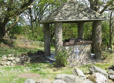
The recently restored wells are near Tara Bay, around 2 miles south east of Portaferry in the shadow of Tieveshilly Hill. No documentary evidence for St Cooey has been discovered, but he lends his name to a number of places in the local area, such as Lough Cowey. The church at St Cooey’s Wells is thought to date from the 7th century but only the foundation stones now remain.

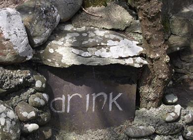
In the mid 1970’s the site was extensively restored by members of the local parish and a modern altar which houses some of the stones was built. Pilgrimage to the site takes place annually on the Sunday nearest to the feast of Saints Peter and Paul. The Washing, Eye and Drinking wells situated in this peaceful, wooded dell are reputed to have healing powers. Certainly, the number of “rags” attached to nearby thorn trees attests to the well’s reputation for healing. A path from the wells leads through a reedbed to the shore where hollows in a slab of rock are said to mark where St Cooey knelt to pray.

Access is from a gate at the car park on Ballyquintin Road. A path and steep steps lead to the wells where seating is available.

Facilities

Attraction Facilities

  • Open Mondays
  • Open Sundays

Parking & Transport

  • On site parking

Guide Prices

Ticket TypeTicket Tariff
TicketFree

Note: Prices are a guide only and may change on a daily basis.

Add St Cooey's Wells to your Itinerary

Close window

Call direct on:

Tel+44 (0) 28 9182 6846

Map & Directions

Opening Times

* Anytime

What's Nearby

  1. Ballyquintin Nature Reserve includes Ballyquintin Point at the tip of the Ards Peninsula,…

    1.22 miles away
  2. Situated on the hill south east of the town below the stump of Portaferry Windmill, a lay…

    2.47 miles away
  3. Portaferry Castle is a 16th Century tower-house, built by the Savage family. It is…

    2.89 miles away
  1. Enjoy a diver's view of marine life from around the world without getting wet. An…

    2.91 miles away
  2. Owned by the National Trust, it is a picturesque 18th century fishing village with scenic…

    3.01 miles away
  3. These ruined churches are situated one and a half miles north east of Portaferry on the…

    3.1 miles away
  4. On the coast, two thirds of a mile south east of Cloughey village. This house appears to…

    4.77 miles away
  5. Within it are the ruins of a medieval church which is believed to be the Church of…

    4.78 miles away
  6. Traditionally believed to have been built by Roland Savage of Ballygalget in 1622,…

    6.57 miles away
  7. Discover how Echlinville Distillery captures the flavour, colour and mouthfeel of their…

    8.18 miles away
  8. Burr Point, the most easterly point on the island.

    9.93 miles away
  9. The Livingston Centre at Killinchy Parish Church is a local heritage centre. It tells the…

    11.06 miles away
  10. Sketrick Castle is located on Sketrick Island which is reached by a causeway on the west…

    11.22 miles away
  11. Nendrum is thought to have been set up by St Machaoi in the 5th Century and also has…

    11.8 miles away
  12. This ruined Tower House commands a position at the north end of Mahee Island in…

    11.98 miles away
  13. Grey Abbey, a Cistercian Abbey church and its living quarters were founded in 1193 by…

    13.06 miles away
Previous Next

Map & Directions

View Maps and Visitor Guides
View of what Ards and North Down has to offer and some of the best things to see and do during a visit.
E-newsletter sign up
Sign up for the Ards and North Down newsletter for inspiration and travel tips.
Back to Top

Tourism Northern Ireland

Don't Miss